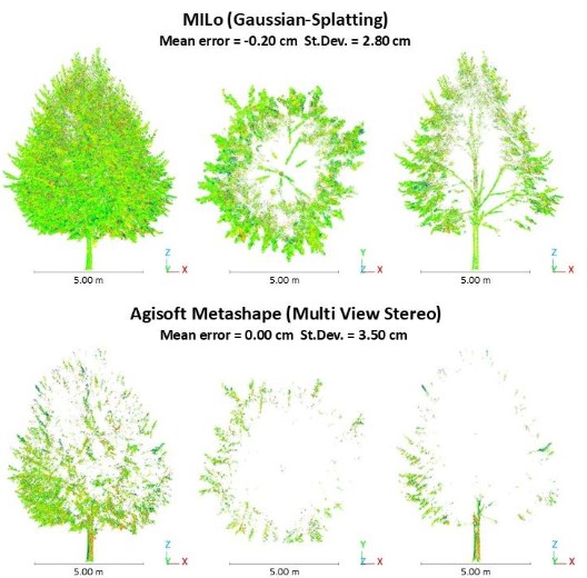
The accurate 3D reconstruction of complex datasets remains an open research challenge, particularly in the case of scenes characterized by vegetation, transparent materials, or non-Lambertian surfaces, which often lead to poor performance of standard multi-view stereo (MVS) techniques. This issue is especially relevant in the cultural heritage field, where many objects and environments such as monumental trees, historic gardens, glazed surfaces, and polished stone materials exhibit exactly these challenging characteristics. In this research, we investigate the use of novel radiance fields (NeRF, Gaussian splats) to generate tangible 3D mesh models especially in the case of challenging surfaces where traditional MVS techniques might fail. In constrast to pure radiance fields where the main objective is novel view synthesis, in this research we focus more on the use of such methods to directly create surface meshes, which can then be used for other purposes such as metric archive or HBIM.
Lead
Dario Billi
Collaborators
Chaimaa Delasse (ICube TRIO & IAV Hassan II)
I Gede Mahendra Dharmawiguna (Monash University)
Related publications
ISPRS Archives
3D Meshing of Challenging Surfaces using Gaussian Splatting
Dario Billi, Chaimaa Delasse, Arnadi Murtiyoso, and 4 more authors
The International Archives of the Photogrammetry, Remote Sensing and Spatial Information Sciences, 2026
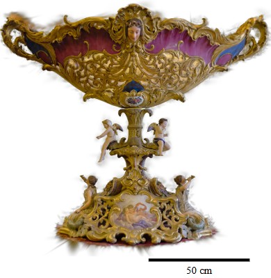
Accurate 3D reconstruction of Cultural Heritage (CH) assets remains a challenging task when scenes include complex geometries and non-Lambertian surfaces, such as dense vegetation, reflective ceramics, or polished materials, which often degrade the performance of traditional multi-view stereo (MVS) pipelines. This work investigates the potential of Mesh-In-the-Loop Gaussian Splatting (MILo), a recent extension of 3D Gaussian Splatting (3DGS) that integrates differentiable mesh extraction directly within the optimization process, enabling bidirectional consistency between volumetric and surface representations. The method is evaluated on three challenging CH datasets: a monumental Tilia tomentosa tree located in a UNESCO-listed urban garden, a reflective ceramic object from the Sarreguemines Earthenware Museum and the South Portal façade of the Notre-Dame Cathedral of Strasbourg. MILo-based reconstructions are compared against standard photogrammetric MVS results generated with Agisoft Metashape, using terrestrial laser scanner (TLS) point clouds as geometric reference. Quantitative accuracy assessment is performed through Multiscale Model-to-Model Cloud Comparison (M3C2), focusing on error distribution, standard deviation, outlier percentage, and preservation of fine-scale structures. Results indicate that while conventional MVS performs slightly better on stable architectural surfaces, MILo significantly improves reconstruction consistency for complex organic geometries, substantially reducing outliers and better preserving thin structures. These findings highlight the suitability of MILo for CH documentation scenarios characterized by challenging surface properties and intricate natural forms.
@article{billi20263d,title={3D Meshing of Challenging Surfaces using Gaussian Splatting},author={Billi, Dario and Delasse, Chaimaa and Murtiyoso, Arnadi and Macher, H{\'e}l{\`e}ne and Grussenmeyer, Pierre and Caroti, Gabriella and Piemonte, Andrea},journal={The International Archives of the Photogrammetry, Remote Sensing and Spatial Information Sciences},volume={49},pages={801--808},year={2026},doi={10.5194/isprs-archives-XLIX-B2-2026-801-2026},dimensions={true},project={mesh},publisher={Copernicus GmbH}}
ISPRS Archives
In-Situ Gaussian Splatting-generated 3D Thermal Mesh Visualization for Urban Trees in Augmented Reality
Chaimaa Delasse, Dario Billi, I Gede Mahendra Darmawiguna, and 6 more authors
The International Archives of the Photogrammetry, Remote Sensing and Spatial Information Sciences, 2026
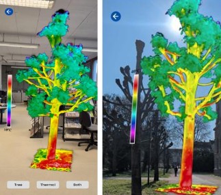
Urban trees provide critical ecosystem services in dense city environments, yet current workflows for monitoring their thermal behaviour remain confined to 2D desktop-based analysis with no three-dimensional spatial context or field-deployable visualization capability. This paper presents a complete pipeline for in-situ 3D thermal mesh visualization of urban trees in Augmented Reality (AR), combining Thermal InfraRed (TIR) image acquisition, Gaussian Splatting-based mesh reconstruction, quantitative validation, and mobile AR deployment. TIR images of a Tilia tomentosa acquired with a FLIR T560 camera are preprocessed with a standardized false-colour palette and fed into the MILo (Mesh-In-the-Loop Gaussian Splatting) framework to reconstruct a thermally attributed 3D mesh. Geometric evaluation against a Z+F IMAGER 5016 TLS reference using the M3C2 algorithm demonstrates that MILo recovers 13.5 times more canopy geometry than traditional multi-view stereo under thermal imagery, with a standard deviation of 4.0 cm. A colourmap inversion procedure recovers per-vertex temperature estimates from the GS-derived mesh colours, yielding a mean absolute difference of 0.7°C against direct T-Cam measurements (thermal camera mounted on the laser scanner), within the combined instrument accuracy of both sensors. The resulting thermal Gaussian Splat was deployed in a custom Android AR application supporting hybrid marker-based and GPS-based spatial anchoring for in-situ visualization. These results demonstrate the technical feasibility of GS-based thermal reconstruction and mobile AR as a medium for communicating three-dimensional canopy thermal information to educators and urban forestry practitioners.
@article{delasse2026situ,title={In-Situ Gaussian Splatting-generated 3D Thermal Mesh Visualization for Urban Trees in Augmented Reality},author={Delasse, Chaimaa and Billi, Dario and Darmawiguna, I Gede Mahendra and Satriadi, Kadek Ananta and Murtiyoso, Arnadi and Macher, H{\'e}l{\`e}ne and Lecomte, Vincent and Hajji, Rafika and Landes, Tania},journal={The International Archives of the Photogrammetry, Remote Sensing and Spatial Information Sciences},volume={49},pages={1021--1028},year={2026},doi={10.5194/isprs-archives-XLIX-B2-2026-1021-2026},dimensions={true},project={mesh},publisher={Copernicus Publications G{\"o}ttingen, Germany}}
ISPRS Archives
Gaussian splatting for the reconstruction of complex and highly detailed object
Sara Gonizzi Barsanti, Dario Billi, Etienne Sommer, and 2 more authors
The International Archives of the Photogrammetry, Remote Sensing and Spatial Information Sciences, 2026
In recent years, Neural Radiance Fields (NeRF) and 3D Gaussian Splatting (3DGS) have emerged as advanced methods for photogrammetry-based 3D reconstruction. Since its introduction in 2020, NeRF has gained significant attention due to its capability to generate high-fidelity reconstructions from multi-view imagery. More recently, 3D Gaussian Splatting (3DGS), introduced in 2023, has proposed an alternative explicit scene representation based on a collection of anisotropic Gaussian primitives optimized directly in 3D space. This representation allows efficient rendering and scalable modelling of complex scenes while maintaining high visual quality. This paper analyses the performance of different 3DGS methods when dealing with complex geometry and less-cooperative surfaces compared to standard SfM IM procedures. Included in the comparison is also the Mesh-In-the-Loop Gaussian Splatting for Detailed and Efficient Surface Reconstruction (MILo), a novel meshing method using Gaussian splats. Three Gaussian splatting methods as implemented in the Postshot commercial software were also tested. Our experiments show that MILo shows very promising results in terms of detail reconstruction, while standard Gaussian splatting excels in visualisation but is still plagued by a high rate of noise especially when converted into a geometric point cloud form.
@article{gonizzi2026gaussian,title={Gaussian splatting for the reconstruction of complex and highly detailed object},author={Gonizzi Barsanti, Sara and Billi, Dario and Sommer, Etienne and Elefante, Erika and Murtiyoso, Arnadi},journal={The International Archives of the Photogrammetry, Remote Sensing and Spatial Information Sciences},volume={49},pages={1355--1361},year={2026},doi={10.5194/isprs-archives-XLIX-B2-2026-1355-2026},dimensions={true},project={mesh},publisher={Copernicus GmbH}}