Recent advancement of radiance field methods such as 3D Gaussian Splatting (3DGS) have achieved a breakthrough in 3D reconstruction. Several derivatives have extended 3DGS with segmentation capabilities. Segmentation of 3D data accelerates surveying workflows by enabling efficient modelling and prediction using spatial data. For an urban heritage complexsite, 3D segmentation would facilitate better scene understanding and provide informed decision-making by the end-users. Therefore, the use of these 3DGS segmentation methods shows promise for these applications. However, the use of real-world data remains underexplored, as it poses some challenges to the segmentation process. This study develops and evaluates 3DGS segmentation methods for heritage sites reconstruction and segmentation. The heterogeneous nature of heritage architectures serve as a challenging test case for the currently available solutions, due to their complex geometric and decorative features.
Lead
Widiatmoko Azis Fadilah
Collaborators
Thodoris Betsas (NTUA)
Virgile Gauthier (ICube TRIO)
Related publications
ISPRS Archives
Exploring Point Transformers on 3D Semantic Segmentation of Javanese Architectures
T. Betsas, A. Murtiyoso, P. Grussenmeyer, and 1 more author
The International Archives of the Photogrammetry, Remote Sensing and Spatial Information Sciences, 2026
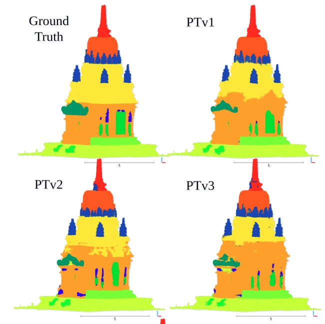
The complex geometry of Javanese architecture poses significant challenges for 3D semantic segmentation in cultural heritage documentation. This study evaluates state-of-the-art Point Transformers, i.e., PTv1, PTv2, PTv3, and LitePT, on the Sewu temple dataset, focusing on robustness and efficiency. While PTv1 and PTv2 achieve the highest Intersection-over-Union (mIoU 0.71), they incur high computational costs. Conversely, LitePT provides an optimal balance, delivering competitive results (0.69 mIoU) while being drastically faster. Furthermore, experiments with limited data reveal the significant benefits of transfer learning from European heritage datasets. We conclude that efficient Point Transformer architectures are promising for the automated understanding of complex non-European monuments.
@article{betsas2026exploring,title={Exploring Point Transformers on 3D Semantic Segmentation of Javanese Architectures},author={Betsas, T. and Murtiyoso, A. and Grussenmeyer, P. and Georgopoulos, A.},journal={The International Archives of the Photogrammetry, Remote Sensing and Spatial Information Sciences},volume={48},pages={57--64},year={2026},doi={10.5194/isprs-archives-XLVIII-2-W12-2026-57-2026},dimensions={true},project={semG},publisher={Copernicus Publications G{\"o}ttingen, Germany}}
ISPRS Archives
Metric Assessment of 3D Gaussian Splatting for UAV-Based Urban Heritage Reconstruction
W.A. Fadilah, A. Murtiyoso, T. Landes, and 1 more author
The International Archives of the Photogrammetry, Remote Sensing and Spatial Information Sciences, 2026
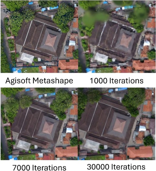
Urban heritage increasingly faces threats from natural disasters and anthropogenic activities, demanding preservation techniques that balance affordability, speed, and accuracy. Real-time rendering with 3D Gaussian Splatting (3DGS) offers immense potential for rapid heritage documentation; however optimal training configurations especially for aerial nadiral images remain limited. This study compares three 3DGS implementations: native 3DGS, Postshot Splat3, and MCMC variants against conventional multi-view stereo using an 80-meter altitude drone aerial imagery. Results reveal some interesting key findings where moderate downsampling of 1/8 resolution can substantially outperform full resolution training. Postshot Splat3 achieved optimal photometric quality while training 21x faster than native implementations. However, geometric analysis showed that rendering quality and geometric accuracy are not correlated. Furthermore, the result suggested that MCMC configurations failed to compete with native 3DGS and Postshot Splat3. These findings suggest that 3DGS-based heritage documentation requires a rather conservative resolution selection and optimized implementation for efficiency to allow cost effective preservation while maintaining dimensional fidelity.
@article{fadilah2026metric,title={Metric Assessment of 3D Gaussian Splatting for UAV-Based Urban Heritage Reconstruction},author={Fadilah, W.A. and Murtiyoso, A. and Landes, T. and Grussenmeyer, P.},journal={The International Archives of the Photogrammetry, Remote Sensing and Spatial Information Sciences},volume={48},pages={143--150},year={2026},doi={10.5194/isprs-archives-XLVIII-2-W12-2026-143-2026},dimensions={true},project={semG},publisher={Copernicus Publications G{\"o}ttingen, Germany}}