publications
2026
- ISPRS Archives
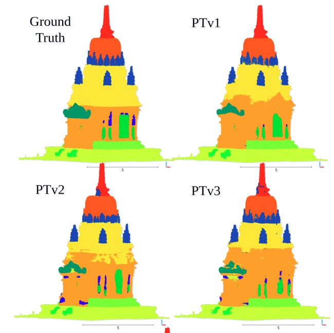 Exploring Point Transformers on 3D Semantic Segmentation of Javanese ArchitecturesT. Betsas, A. Murtiyoso, P. Grussenmeyer, and 1 more authorThe International Archives of the Photogrammetry, Remote Sensing and Spatial Information Sciences, 2026
The complex geometry of Javanese architecture poses significant challenges for 3D semantic segmentation in cultural heritage documentation. This study evaluates state-of-the-art Point Transformers, i.e., PTv1, PTv2, PTv3, and LitePT, on the Sewu temple dataset, focusing on robustness and efficiency. While PTv1 and PTv2 achieve the highest Intersection-over-Union (mIoU 0.71), they incur high computational costs. Conversely, LitePT provides an optimal balance, delivering competitive results (0.69 mIoU) while being drastically faster. Furthermore, experiments with limited data reveal the significant benefits of transfer learning from European heritage datasets. We conclude that efficient Point Transformer architectures are promising for the automated understanding of complex non-European monuments.
@article{betsas2026exploring, title = {Exploring Point Transformers on 3D Semantic Segmentation of Javanese Architectures}, author = {Betsas, T. and Murtiyoso, A. and Grussenmeyer, P. and Georgopoulos, A.}, journal = {The International Archives of the Photogrammetry, Remote Sensing and Spatial Information Sciences}, volume = {48}, pages = {57--64}, year = {2026}, doi = {10.5194/isprs-archives-XLVIII-2-W12-2026-57-2026}, dimensions = {true}, project = {semG}, publisher = {Copernicus Publications G{\"o}ttingen, Germany} } - ISPRS Archives
 Plane-Intersection Reconstruction of Integrated Point Clouds toward Property Valuation-Oriented 3D Building ModelsR. Widyastuti, D. Suwardhi, A. Hernandi, and 3 more authorsThe International Archives of the Photogrammetry, Remote Sensing and Spatial Information Sciences, 2026
Three-dimensional (3D) building models with a high level of geometric and semantic detail are increasingly required to support fiscal cadastral applications, such as property valuation and taxation. In dense urban environments, however, the availability of complete and high-quality 3D data remains limited, particularly for exterior wall information. This research proposes a rule-based 3D building reconstruction workflow using integrated Unmanned Aerial Vehicle-Light-Detection and Ranging (UAV-LiDAR) and terrestrial handheld scanner point clouds to generate building models with hanging roofs and explicit building elements. The proposed method combines region growing segmentation for roof and exterior wall extraction, planar surface reconstruction through plane fitting, and geometric primitive intersection to construct roof meshes and building envelopes. Roof geometry is reconstructed from planar roof components, while exterior wall points are used to adjust the building envelope and support hanging roof modelling. The resulting 3D building model is represented as separated elements, including roof, exterior walls, and floor surfaces, enabling element-based area calculation and cost estimation for fiscal cadastral purposes. Quantitative evaluation using point cloud-to-model distance analysis shows that the reconstruction accuracy falls within the commonly reported range for Level of Detail 2 (LoD2) building models, despite limitations caused by segmentation precision and parameter sensitivity of rule-based algorithms. The results demonstrate that the proposed approach provides a feasible solution for 3D building modelling in environments with incomplete data, while supporting transparent and assessment-oriented fiscal cadastral workflows.
@article{widyastuti2026plane, title = {Plane-Intersection Reconstruction of Integrated Point Clouds toward Property Valuation-Oriented 3D Building Models}, author = {Widyastuti, R. and Suwardhi, D. and Hernandi, A. and Siagian, D.A.P. and Murtiyoso, A. and Remondino, F.}, journal = {The International Archives of the Photogrammetry, Remote Sensing and Spatial Information Sciences}, volume = {48}, pages = {503--509}, year = {2026}, doi = {10.5194/isprs-archives-XLVIII-2-W12-2026-503-2026}, dimensions = {true}, publisher = {Copernicus GmbH} } - ISPRS Archives
 Metric Assessment of 3D Gaussian Splatting for UAV-Based Urban Heritage ReconstructionW.A. Fadilah, A. Murtiyoso, T. Landes, and 1 more authorThe International Archives of the Photogrammetry, Remote Sensing and Spatial Information Sciences, 2026
Urban heritage increasingly faces threats from natural disasters and anthropogenic activities, demanding preservation techniques that balance affordability, speed, and accuracy. Real-time rendering with 3D Gaussian Splatting (3DGS) offers immense potential for rapid heritage documentation; however optimal training configurations especially for aerial nadiral images remain limited. This study compares three 3DGS implementations: native 3DGS, Postshot Splat3, and MCMC variants against conventional multi-view stereo using an 80-meter altitude drone aerial imagery. Results reveal some interesting key findings where moderate downsampling of 1/8 resolution can substantially outperform full resolution training. Postshot Splat3 achieved optimal photometric quality while training 21x faster than native implementations. However, geometric analysis showed that rendering quality and geometric accuracy are not correlated. Furthermore, the result suggested that MCMC configurations failed to compete with native 3DGS and Postshot Splat3. These findings suggest that 3DGS-based heritage documentation requires a rather conservative resolution selection and optimized implementation for efficiency to allow cost effective preservation while maintaining dimensional fidelity.
@article{fadilah2026metric, title = {Metric Assessment of 3D Gaussian Splatting for UAV-Based Urban Heritage Reconstruction}, author = {Fadilah, W.A. and Murtiyoso, A. and Landes, T. and Grussenmeyer, P.}, journal = {The International Archives of the Photogrammetry, Remote Sensing and Spatial Information Sciences}, volume = {48}, pages = {143--150}, year = {2026}, doi = {10.5194/isprs-archives-XLVIII-2-W12-2026-143-2026}, dimensions = {true}, project = {semG}, publisher = {Copernicus Publications G{\"o}ttingen, Germany} } - ISPRS Archives
 Integrating Terrestrial Laser Scanning and 3D Gaussian Splatting for Heritage Building Documentation and MonitoringD. Suwardhi, L.K. Agustina, W. Andika, and 4 more authorsThe International Archives of the Photogrammetry, Remote Sensing and Spatial Information Sciences, 2026
Accurate and reliable 3D documentation is important for the conservation and long-term monitoring of heritage buildings, where both metric precision and visual interpretability are required. This paper presents a co-registered hybrid 3D information model for heritage buildings, integrating Terrestrial Laser Scanning (TLS), Historic Building Information Modelling (HBIM), and 3D Gaussian Splatting (3DGS). The approach is demonstrated through a case study of Aula Timur ITB, a nationally protected heritage building in Indonesia. TLS data serve as the geometric backbone of the framework, providing survey-grade spatial reference. An HBIM model is generated from the TLS point clouds and structured using the Industry Foundation Classes (IFC) standard, ensuring that semantic building components are co-registered with the metric geometry. In parallel, a photorealistic 3DGS representation is generated from image-based reconstruction and rigidly aligned to the same TLS reference frame. Rather than producing a single fused geometry, the proposed integration results in a multi-layer representation in which metric, semantic, and radiance-field-based models coexist within a shared spatial reference. Quantitative alignment metrics, including transformation residuals, and cloud-to-cloud distance analysis, are used to assess geometric consistency between TLS and 3DGS. The integrated model is deployed in an immersive VR/MR environment to support intuitive navigation and visual inspection tasks. The results demonstrate that anchoring 3DGS to survey-grade geometry enables photorealistic real-time visualization while preserving spatial reliability, making the approach suitable for heritage documentation and monitoring scenarios. The proposed workflow highlights the complementary roles of metric surveying, information modelling, and emerging radiance-field representations in heritage-oriented 3D information systems.
@article{suwardhi2026integrating, title = {Integrating Terrestrial Laser Scanning and 3D Gaussian Splatting for Heritage Building Documentation and Monitoring}, author = {Suwardhi, D. and Agustina, L.K. and Andika, W. and Widyastuti, R. and Fadilah, W.A. and Murtiyoso, A. and Remondino, F.}, journal = {The International Archives of the Photogrammetry, Remote Sensing and Spatial Information Sciences}, volume = {48}, pages = {463--470}, year = {2026}, doi = {10.5194/isprs-archives-XLVIII-2-W12-2026-463-2026}, dimensions = {true}, publisher = {Copernicus Publications G{\"o}ttingen, Germany} } - CFS
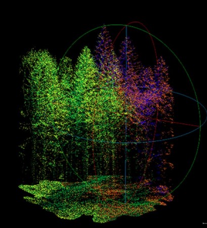 Trends and Developments in the Realm of Virtual Forest VisualizationS.K.P. Kushwaha, H. Hristova, C. Fol, and 9 more authorsCurrent Forestry Reports, 2026
We examine key trends, developments, and challenges according to the global research in the use of 2D and 3D visualization for virtual forest experiences and present selected case studies. We describe the potential of virtual forest visualization for applications in forest management, conservation, education, and research. We also present an opportunity to utilize and develop further the scope of visualization using these latest technologies in forestry globally.
@article{kushwaha2026trends,
  title = {Trends and Developments in the Realm of Virtual Forest Visualization},
  author = {Kushwaha, S.K.P. and Hristova, H. and Fol, C. and Hands, T. and Murtiyoso, A. and Coltekin, A. and Fedosov, A. and Holm, S. and Costa, M. and Bugmann, H. and Griess, V.C. and Schweier, J.},
  journal = {Current Forestry Reports},
  volume = {12},
  number = {1},
  pages = {3},
  year = {2026},
  doi = {10.1007/s40725-025-00265-5},
  dimensions = {true},
  publisher = {Springer International Publishing}
}
2025
- ISPRS Archives
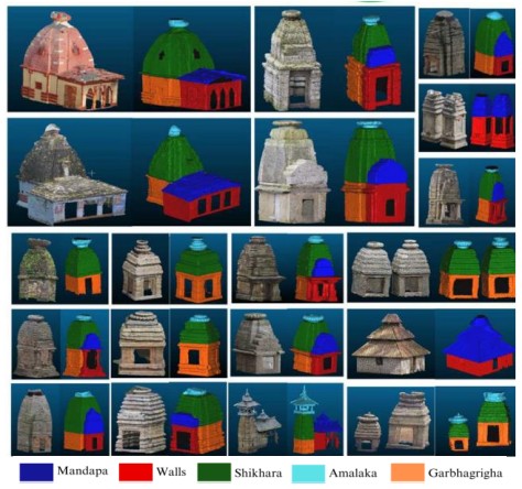 Cross-domain urban and heritage point cloud benchmarks for semantic segmentation: insights from the 3M (Mapping Mappano Municipality) and ArCHX datasetsF. Matrone, A. Lingua, A. Murtiyoso, and 7 more authorsThe International Archives of the Photogrammetry, Remote Sensing and Spatial Information Sciences, 2025
Semantic segmentation of 3D point clouds is a key enabler for intelligent urban analysis and cultural heritage documentation. However, current benchmarks remain uneven for different reasons: from the fragmented scenes of cityscape scenarios where a unique environment is not provided, to the difficulties in representing the great variety of architectural styles and lexicons in the cultural heritage (CH) domain. This study introduces two complementary datasets, the 3M (Mapping Mappano Municipality) dataset and the ArCHX (Architectural Cultural Heritage eXpanded) dataset, meant to enhance cross-domain learning between urban and architectural heritage environments. The 3M dataset, derived from UAV photogrammetry and GNSS-based surveys over an 11.9 km² area near Turin (Italy), provides a highly accurate, semantically labelled urban point cloud ( 900 M points) suitable for urban planning, automatic mapping, and infrastructure design. In parallel, the ArCHX dataset extends the existing ArCH benchmark with new scenes from Portuguese masonry gates and Indian Nagara-style temples, reaching over 400 million points. These additions diversify architectural typologies and improve the generalisation capacity of AI models applied to heritage semantic segmentation tasks. Methodological challenges in harmonising class taxonomies, managing heterogeneous materials, and aligning cultural architectural semantics across datasets are eventually discussed. Collectively, the 3M and ArCHX datasets establish a novel foundation for cross-domain benchmarking in 3D semantic segmentation, advancing data-driven research in digital twins, mapping, Historic Building Information Modelling (HBIM), and AI-assisted heritage documentation.
@article{matrone2025cross, title = {Cross-domain urban and heritage point cloud benchmarks for semantic segmentation: insights from the 3M (Mapping Mappano Municipality) and ArCHX datasets}, author = {Matrone, F. and Lingua, A. and Murtiyoso, A. and Sridhar, M. and Sanchez Aparicio, L.J. and Santamaria Maestro, R. and Sanz-Honrado, P. and Pande, H. and Seth Tiwari, P. and Agrawal, S.}, journal = {The International Archives of the Photogrammetry, Remote Sensing and Spatial Information Sciences}, volume = {XLVIII-1/W6-2025}, pages = {131--137}, year = {2025}, doi = {10.5194/isprs-archives-XLVIII-1-W6-2025-131-2025}, dimensions = {true}, publisher = {Copernicus}, } - IEEE Xplore
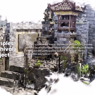 3D Gaussian Splatting for Archival of Balinese Temples from Community-Sourced VideosA. Wilson, A. Murtiyoso, B. Jenny, and 5 more authorsIn 2025 IEEE International Conference on Imaging Systems and Techniques (IST), 2025
We present a novel application of 3D Gaussian Splatting (3DGS) for the large-scale archival of thousands of temples in Bali. Our project, the Bali Digital Heritage Initiative, adopts a participatory approach in which local communities collect video footage of these vulnerable temples, which we transform into 3DGS scenes to serve as digital archives. Unlike existing approaches that require uploading curated sets of images, video contribution simplifies the process for the community. We expect this to encourage a high participation rate and increase the number of archived temples. However, these community-sourced videos are often of variable quality and usually aren’t ideal for 3D reconstruction, introducing technical challenges. This paper first presents several key challenges in the development of the 3DGS pipeline in this context, including managing video quality, combining multiple videos, ensuring reliable results from Structure from Motion, and maintaining the visual quality of 3DGS scenes. We then propose and test solutions to many of these challenges, addressing all parts of the reconstruction pipeline. We also introduce a postprocessing stage that cleans up the scene through a series of purpose-built 3DGS filters, which consider attributes of Gaussian primitives, including local density, geometry, and colors. Finally, we discuss future research directions to address unsolved problems and improve the performance of the pipeline.
@inproceedings{wilson20253d, title = {3D Gaussian Splatting for Archival of Balinese Temples from Community-Sourced Videos}, author = {Wilson, A. and Murtiyoso, A. and Jenny, B. and Darmawiguna, I.G.M. and Suputra, P.H. and Chandler, T. and Kesiman, M.W.A. and Satriadi, K.A.}, booktitle = {2025 IEEE International Conference on Imaging Systems and Techniques (IST)}, pages = {1--6}, year = {2025}, doi = {10.1109/IST66504.2025.11268436}, dimensions = {true}, publisher = {IEEE}, project = {GS3D} } - IEEE Xplore
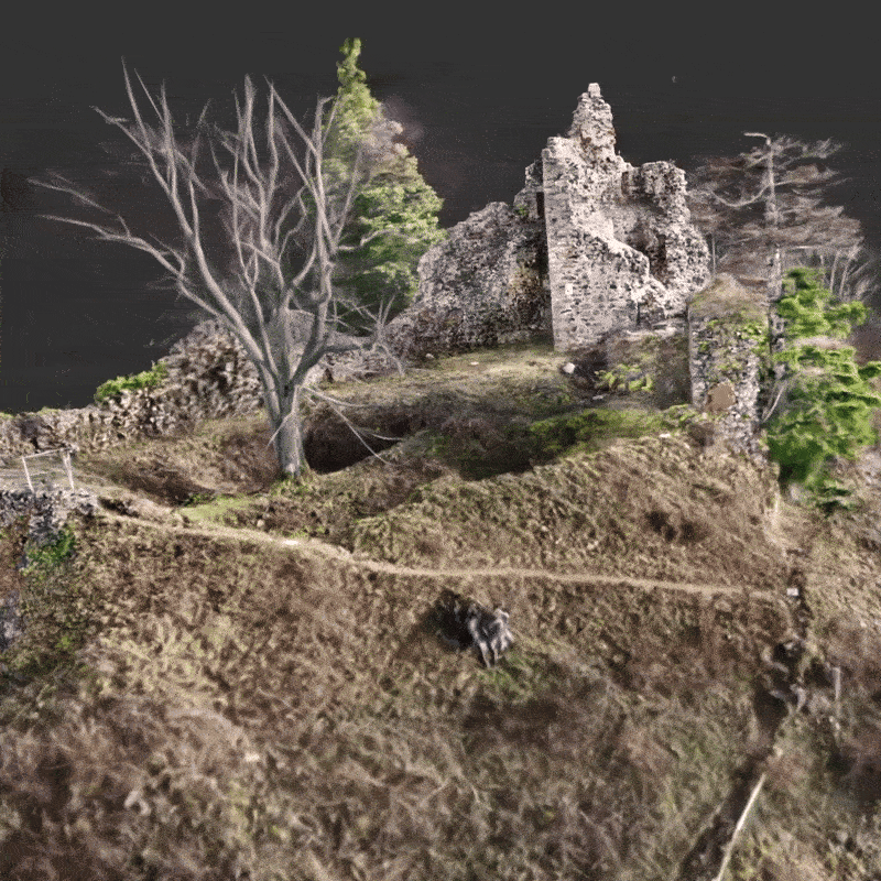 Radiance Fields for Archaeological Documentation of Medieval Rhine Valley Castle RuinsE. Sommer, A. Murtiyoso, M. Koehl, and 1 more authorIn 2025 IEEE International Conference on Imaging Systems and Techniques (IST), 2025
This study investigates the use of Gaussian Splatting for 3D reconstruction of medieval castle ruins in the Rhine Valley, comparing its effectiveness with conventional photogrammetry. 3D Gaussian Splatting (3DGS), a recent real-time rendering technique, models scenes using point-based representations with anisotropic Gaussians, enabling high-fidelity reconstructions from sparse image inputs. Unlike traditional photogrammetry, which depends on dense point clouds and mesh generation, 3DGS offers smoother rendering, better handling of fine details, and improved performance in visually complex or degraded areas. 3DGS excels in producing visually compelling, immersive models with fewer artifacts in occluded or texture-deficient regions. In this paper, three analyses were performed by focusing on three individual aspects: processing time, geometric accuracy, and visual quality. Our study’s results highlight the advantages of 3DGS in this regard, which include quick data processing time and excellent visualisation capability specifically with finely detailed objects. However, this method still faces challenges when employed for a metric archiving of built heritage, where traditional photogrammetry still provides a higher quality metric result using the same input data. 3DGS suffers particularly from noisy data, especially when converted into point clouds. Nevertheless, this approach presents a promising tool for digital heritage preservation, enabling efficient and realistic visualisation of fragile historical sites.
@inproceedings{sommer2025radiance, title = {Radiance Fields for Archaeological Documentation of Medieval Rhine Valley Castle Ruins}, author = {Sommer, E. and Murtiyoso, A. and Koehl, M. and Grussenmeyer, P.}, booktitle = {2025 IEEE International Conference on Imaging Systems and Techniques (IST)}, pages = {1--6}, year = {2025}, doi = {10.1109/IST66504.2025.11268408}, dimensions = {true}, publisher = {IEEE}, project = {GS3D} } - ISPRS Archives
 Integrative AI for the Understanding of Ancient Javanese ArchitecturesA. Murtiyoso, G. Mazzacca, F. Remondino, and 1 more authorThe International Archives of the Photogrammetry, Remote Sensing and Spatial Information Sciences, 2025
The use of digital techniques has seen an increasing amount of use in recent years for heritage documentation. The development of artificial intelligence (AI) also contributed to this rise, with many different applications to help facilitate the heritage recording process. A by-product of these developments is the increasing amount of available data, in tandem with the ever-increasing need for training data for AI purposes. This paper aims to re-use old datasets and repurpose them using modern methods. The objective is therefore to see if older datasets may be used to improve the quality of AI-based methods, while also investigating the use of new technologies such as Visual Language Models (VLM) to perform semantic queries and Gaussian splatting on these datasets. For this purpose, datasets from a previous documentation project involving Javanese “candi” architecture is used in this paper since this particular subject has not seen too many AI-based documentation research in the literature and is thus an interesting example to evaluate the generalisation of AI methods. Results show that old datasets can very well be used with modern techniques with promising results. In terms of semantic segmentation, machine learning yielded an overall accuracy of 0.89 while deep learning yielded 0.79. Several interesting inferences were also observed in the VLM query results, while Gaussian splatting showed very strong potential for visualisation-based applications to further enhance the reusability of these old datasets.
@article{isprs-archives-XLVIII-M-9-2025-1065-2025, author = {Murtiyoso, A. and Mazzacca, G. and Remondino, F. and Suwardhi, D.}, title = {Integrative AI for the Understanding of Ancient Javanese Architectures}, journal = {The International Archives of the Photogrammetry, Remote Sensing and Spatial Information Sciences}, volume = {XLVIII-M-9-2025}, year = {2025}, pages = {1065--1072}, doi = {10.5194/isprs-archives-XLVIII-M-9-2025-1065-2025}, dimensions = {true}, publisher = {Copernicus}, } - ISPRS Archives
 Gaussian Splatting for Facade Orthophoto Generation – Comparison with MVS and TLSA. Murtiyoso and H. MacherThe International Archives of the Photogrammetry, Remote Sensing and Spatial Information Sciences, 2025
The notion of radiance fields is a very recent topic which has gained much traction in the past couple of years. Among some of the well known techniques, 3D Gaussian splatting (3DGS) seems to generate promising results in terms of 3D reconstruction. In the domain of heritage documentation, orthophotos are a standard product usually generated from photogrammetry by projecting image pixels into a 3D surface created from depth maps or point clouds. In this paper we investigate the possibility to substitute the conventional method for 3D surface generation, either terrestrial laser scanning (TLS) or multi-view stereo (MVS), with 3DGS. The paper will attempt to answer two questions: (1) whether this novel method is a viable solution for orthophoto generation within the heritage documentation context, and (2) at what point is 3DGS worth the time and effort to reach an acceptable orthophoto when compared to conventional methods. To do this, we perform multiple analysis on both the geometric quality of point clouds and the orthophotos themselves, using conventional TLS data as our reference. Our results indicate that 3DGS is not only promising, but indeed a viable alternative to conventional MVS with a potential gain of processing time between 12% up to 33% to reach a comparable quality. In the scenarios tested, both of these gains came with an average point cloud standard deviation of 2 cm.
@article{isprs-archives-XLVIII-M-9-2025-1059-2025, author = {Murtiyoso, A. and Macher, H.}, title = {Gaussian Splatting for Facade Orthophoto Generation – Comparison with MVS and TLS}, journal = {The International Archives of the Photogrammetry, Remote Sensing and Spatial Information Sciences}, volume = {XLVIII-M-9-2025}, year = {2025}, pages = {1059--1064}, doi = {10.5194/isprs-archives-XLVIII-M-9-2025-1059-2025}, dimensions = {true}, publisher = {Copernicus}, project = {GS3D}, } - ISPRS Archives
 Initial Experiments on the Use of Radiance Fields for Underwater 3D ReconstructionB. Tanduo, F. Matrone, and A. MurtiyosoThe International Archives of the Photogrammetry, Remote Sensing and Spatial Information Sciences, 2025
Underwater photogrammetry presents unique challenges, including light attenuation, refraction, and turbidity, that affect the accuracy and quality of 3D reconstructions. This study investigates the performance of novel neural rendering techniques, Neural Radiance Fields (NeRF), SeaThru-NeRF, and 3D Gaussian Splatting (3DGS), in comparison to conventional Structure-from-Motion (SfM) workflows. Using a dataset acquired during the SIFET benchmark campaign on a submerged Roman archaeological site, we processed image data via Nerfacto, SeaThru, and Jawset Postshot (3DGS) and compared outputs against a reference model produced in Agisoft Metashape. Evaluation criteria included processing time, geometric accuracy (via M3C2 analysis), point cloud density and roughness, and point cloud completeness. Results show that radiance fields-based methods significantly reduce processing time while providing competitive visual results. SeaThru-NeRF demonstrated the highest geometric accuracy, benefiting from underwater-specific corrections, while 3DGS offered photorealistic rendering. These findings highlight the potential of neural methods for underwater cultural heritage documentation, though further improvements are needed in data fidelity and robustness under challenging underwater conditions.
@article{isprs-archives-XLVIII-M-9-2025-1475-2025, author = {Tanduo, B. and Matrone, F. and Murtiyoso, A.}, title = {Initial Experiments on the Use of Radiance Fields for Underwater 3D Reconstruction}, journal = {The International Archives of the Photogrammetry, Remote Sensing and Spatial Information Sciences}, volume = {XLVIII-M-9-2025}, year = {2025}, pages = {1475--1481}, doi = {10.5194/isprs-archives-XLVIII-M-9-2025-1475-2025}, dimensions = {true}, publisher = {Copernicus}, project = {GS3D}, } - ISPRS Archives
 Implementing 3D Augmented Reality for Increasing Public Outreach of Majapahit Archeological SitesF. Bioresita, H. Hidayat, A. Murtiyoso, and 5 more authorsThe International Archives of the Photogrammetry, Remote Sensing and Spatial Information Sciences, 2025
Cultural heritage sites, such as historical buildings and monuments, hold significant artistic, cultural, and historical value which necessitates preservation. This study explores the integration of 3D modelling and Augmented Reality (AR) technologies to digitally document and promote public engagement with heritage sites. Employing both laser scanning and photogrammetry, the research aims to develop accurate and photorealistic 3D models of key archaeological structures from the Majapahit era located in Trowulan, Indonesia—specifically Bajang Ratu, Wringin Lawang, and Brahu. Laser scanning demonstrates superior geometric accuracy and spatial completeness, producing denser point clouds and more detailed meshes, which are essential for precise documentation, restoration planning, and structural analysis. Photogrammetry, while offering lower geometric resolution, excels in capturing high-quality surface textures, making it more suitable for visual representation, public engagement, and AR applications. The findings highlight the benefits of a hybrid approach that combines laser scanning’s spatial precision with photogrammetry’s visual realism. This AR experience, when paired with a printed archaeological site map, allows users to interact with the digital reconstructions, enhancing historical understanding and accessibility. Furthermore, this research contributes to digital conservation efforts and innovative historical learning methods for Indonesian cultural heritage.
@article{isprs-archives-XLVIII-M-9-2025-141-2025,
  author = {Bioresita, F. and Hidayat, H. and Murtiyoso, A. and Moisan, E. and Grussenmeyer, P. and Cahyadi, M. N. and Cahyono, A. B. and Maulana, I.},
  title = {Implementing 3D Augmented Reality for Increasing Public Outreach of Majapahit Archeological Sites},
  journal = {The International Archives of the Photogrammetry, Remote Sensing and Spatial Information Sciences},
  volume = {XLVIII-M-9-2025},
  year = {2025},
  pages = {141--147},
  doi = {10.5194/isprs-archives-XLVIII-M-9-2025-141-2025},
  dimensions = {true},
  publisher = {Copernicus},
}
2024
- ISPRS Archives
 Comparison of state-of-the-art multi-view stereo solutions for close range heritage documentationA. Murtiyoso, J.S. Markiewicz, A.K. Karwel, and 2 more authorsInternational Archives of the Photogrammetry, Remote Sensing and Spatial Information Sciences, 2024
In recent years novel 3D reconstruction methods have been developed to improve the conventional image-based point cloud generation techniques. These novel methods generally attempt to address various challenges encountered in conventional methods, namely, the reconstruction of reflective surfaces and the amount of processing time required, both of which are major bottlenecks in heritage documentation and especially those related to large and complex objects. In this paper, we identified three types of 3D image-based reconstruction techniques and tested their usage on heritage datasets, namely (1) conventional multi-view stereo (MVS), (2) learning-based MVS, and (3) neural radiance fields (NeRF). The aim of this study is to determine the capabilities of these methods in reconstruction of three different heritage-related datasets with different challenges. Our results show that conventional MVS is nowadays a reliable solution for 3D reconstruction, in many instances recording good results relative to the reference terrestrial laser scans (TLS) when properly deployed. When applied to a challenging highly reflective scene, conventional MVS fared well using the PatchMatch algorithm (reaching an object completeness rate of 99.05%), while NeRF’s best performance was 99.98%. However, NeRF suffered from noisy data, some of which may stem from its radiance field-to-point cloud conversion method. The results show that there is great potential in using specific methods for specific cases, and research in combining them may yield interesting results in the future.
@article{murtiyoso2024comparison,
  title = {Comparison of state-of-the-art multi-view stereo solutions for close range heritage documentation},
  author = {Murtiyoso, A. and Markiewicz, J.S. and Karwel, A.K. and Grussenmeyer, P. and Kot, P.},
  journal = {International Archives of the Photogrammetry, Remote Sensing and Spatial Information Sciences},
  volume = {48},
  number = {2},
  pages = {317--323},
  year = {2024},
  doi = {10.5194/isprs-archives-XLVIII-2-W4-2024-317-2024},
  dimensions = {true},
  publisher = {Copernicus},
  project = {GS3D},
}